Techado Negro and Aguja Volonqui

The east side of Aguja Volonqui, viewed from near the top of Domo Blanco. The Comesaña-Fonrouge is marked with red dots, and "El Lobito" in green dots.

The last couple weeks in El Chalten the weather has been neither particularly good nor bad. There hasn’t been a lot of truly burly storms, but there haven’t been any periods of weather forecast good enough to feel confident about trying big, hard routes. There have been a handful of decent days, however, and Sarah and I used a couple of them to tag summits that we’ve never been to before.

On November 30th we made a day-trip from town up Cerro Techado Negro, one of the less-spectacular peaks around, but a close option for alpine climbing. The logical approaches to Techado Negro are from either Laguna Sucia or Laguna Torre. We chose to approach from Laguna Torre, and I think it was the faster, easier option, at least in early season when the approach gully is filled with snow. While straightforward, the snow in our approach gully was in terrible condition on the 30th (it was the first very warm day after periods of heavy snowfall), and getting up to the base of the real climbing was much slower and more tiring than it could’ve been with firm snow.

We climbed Techado Negro via the southeast face, which was a mix of snow gully and 4th-class rock – just barely easy enough that we simul-soloed to the summit, but just barely difficult enough that we made a few short rappels on the way down. When we climbed Cerro Mojon Rojo last year we were amazed by the rock quality – Techado Negro, on the other hand, is made of quite loose rock, that wouldn’t be very fun for difficult climbing.

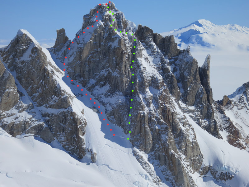
A few days later the forecast looked good enough to perhaps try something a bit bigger, so on the 4th we hiked into the Marconi Valley with plans for Aguja Volonqui. Aguja Volonqui is the highest summit between Cerro Rincon and Cerro Marconi, and was first climbed in 1976 by Rab Carrington and Alan Rouse. Carrington and Rouse climbed snow slopes to the col south of the summit, and then mixed terrain on the east side of the south ridge. While I was climbing Cerro Domo Blanco this past September, I spied an intriguing-looking ice gully on the east buttress, so Sarah and I planned to try that.

When we woke up early on the 5th it was fairly windy, but we figured we might as well start approaching, and if we were lucky things would calm down. Luckily things went in our favor, and by the time we were roped up and climbing the wind was mellowing out. There was also a fair amount of cloud cover, which was another boon, as the approach took longer than expected, and we were starting an east-facing ice route later than we should have been.

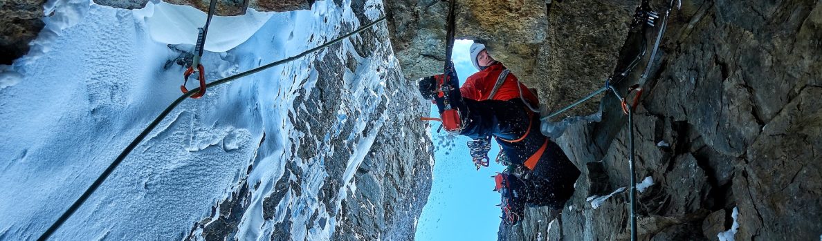
The climb turned out to be quite a fun ice and mixed route. There was some steep snow, some moderate mixed climbing, one pitch of steep ice, a bunch of mellow ice, and one pitch of tricky thin ice. The hardest climbing was perhaps the last pitch (roughly M5), which involved one move of A0 pulling on a cam, and then a mantel onto the ridge just 10 meters horizontally away from the summit boulder. We descended the Carrington-Rouse route via a combination of rappelling and down-climbing. We named our route “El Lobito,” (400m, AI4+, M5, A0) and I would recommend it for a fun ice and mixed climb.


Sunrise on the Adelas and Torres while hiking in to Techado Negro.
Looking up our approach gully from Laguna Torre to Techado Negro. Techado Negro is the summit on the left, and the summit on the right is Cerro Ñire.
Colin kicking steps up our approach gully to Techado Negro. Cerro Ñire is the summit above. Photo by Sarah Hart.
Sarah nearing the col to the south of Techado Negro, with Cerro Huemul and Cerro Solo behind.
Colin at the col south of Techado Negro, with the souteast aspect above. Photo by Sarah Hart.

Looking out upon Cerro Ñire, from part way up Techado Negro.


Sarah simul-soloing 4th-class rock on the southeast side of Techado Negro.


Sarah negotiating some chossy rock near the top of Techado Negro.


Colin tagging the summit of Techado Negro. There was another pinnacle about 50m to the west that looked like it might have been 1 or 2 meters higher than this one, although it was difficult to tell for sure. Photo by Sarah hart.


Sarah breaking trail up to the base of Aguja Volonqui. Cerro Rincon is to the left, with the Colmillos between it and Aguja Volonqui on the right.


Sarah arriving at the base of "El Lobito," after crossing the bergschrund.
Sarah arriving at the base of “El Lobito,” after crossing the bergschrund.


Colin racking up at the base of "El Lobito." Photo by Sarah Hart.
Colin racking up at the base of “El Lobito.” Photo by Sarah Hart.
Sarah climbing up to the base of the waterfall pitch.


A nice view of Cerro Piergiorgio and Cerro Domo Blanco from low on "El Lobito."
A nice view of Cerro Piergiorgio and Cerro Domo Blanco from low on “El Lobito.”


Colin leading the waterfall pitch, which turned out to be harder than it looked, mostly because the ice was not all good quality. Photo by Sarah Hart.


Looking down the waterfall pitch.


Sarah about midway up "El Lobito."
Sarah about midway up “El Lobito.”


Sarah following a pitch of thin ice.
Sarah on traversing terrain near the top of Volonqui's east face.
Sarah on traversing terrain near the top of Volonqui’s east face.


Colin traversing near the top of Volonqui's east face. Photo by Sarah Hart.
Colin traversing near the top of Volonqui’s east face. Photo by Sarah Hart.


Sarah following the second-to-last pitch on "El Lobito."
Sarah following the second-to-last pitch on “El Lobito.”


Colin just below the summit of Aguja Volonqui. "El Lobito" arrived on the ridge from immediately below and left. Photo by Sarah Hart.
Colin just below the summit of Aguja Volonqui. “El Lobito” arrived on the ridge from immediately below and left. Photo by Sarah Hart.


On top of Aguja Volonqui, I believe for its second ascent.
Colin starting the first rappel down the Carrington-Rouse. Photo by Sarah Hart.


A nice view of Bifida and the Torres from the base of Volonqui's east face.
A nice view of Bifida and the Torres from the base of Volonqui’s east face.


Sarah down-climbing steep snow on the lower portion of the Carrington-Rouse, with the Torres behind.


Colin looking sad at the base of the Marconi Glacier, about to eat our last two morsels of food before the hike out. Photo by Sarah Hart.


The east side of Aguja Volonqui, viewed from near the top of Domo Blanco. The Comesaña-Fonrouge is marked with red dots, and "El Lobito" in green dots.
The east side of Aguja Volonqui, viewed from near the top of Domo Blanco. The Comesaña-Fonrouge is marked with red dots, and “El Lobito” in green dots.